Grissell Hay Lodging House Historical Report, Block 29 Building I Lot 171Originally entitled: "Archibald Blair House Block 29, Colonial Lot 171"
Colonial Williamsburg Foundation Library Research Report Series - 1559
Colonial Williamsburg Foundation Library
Williamsburg, Virginia
1990
ARCHIBALD BLAIR HOUSE
Block 292 Colonial Lot 171
LOCATION:
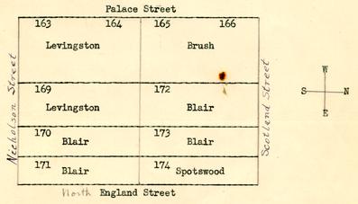
The lot (#171) on which the "Archibald Blair House" was erected, is bounded on the south by Nicholson Street, east by England Street, west by the lot of St. George Tucker, and on the north by lot 174. (See Tyler's adaptation of the College Map, Illustration #1.)
HISTORY:
Court records of the early eighteenth century indicate that lot 171 was conveyed on July 15, 1716, by the trustees of Williamsburg to Archibald Blair1 of James City County. In the same grant Blair received, also, lots 170, 172, and 173:
2 It would appear that Blair erected a dwelling upon the lot sometime within a period of two years, since there is no record of the lot having escheated to the city.July 15, 1716
Trustees City of Williamsburg
to
Blair, Archibald of James City County
Consideration: 3 PoundsFour certain lots of ground in the city of Williamsburg denoted in the plot of the said city by the figures 170, 171, 172 and 173. ... Shall begin to build within 24 months upon each lot one or more good dwellings according to an Act of Assembly of 1705.
(York County Records, Deeds, Bonds, Book III, pp. 126-7)
Below is a drawing by the writer of this report which shows the ownerships of all lots on the block in 1716-1717. The titles to the lots are so closely related that it seems well to give the reader this picture:
In July 1724, Archibald Blair gained possession of the Spotswood lot (#174) via John Randolph1 late purchaser, the lot being described as "adjoining to the garden of the said Archibald Blair":2
3 With the Spotswood lot added to his other lots, Blair was in possession of five Williamsburg lots: 170, 171, 172, 173 and 174, and also of lots 163, 164 and 169 acquired by mortgage.1XJuly 20, 1724
Randolph, John
to
Blair, Archibald
Consideration: 30 PoundsAll that messuage and lot or half acre of land situate, lying and being in the City of Williamsburg, adjoining to the garden of the said Archibald Blair, which the said John lately purchased of the Hon. Alexander Spotswood.
(York County Records, Deeds, Bonds, Book III, p. 424)
Blair undoubtedly held the above named lots until his death in 1735. Subsequent deeds (April 13, 1759) to contiguous property state that John Blair was executor of the last will and testament of Archibald Blair, decd., under indenture of February 20, 1735. (York County Records, Deeds, Book VI, pp. 184-85.)
Just when the lots (170, 171, 172, 173, 174) were conveyed to John Randolph2 is not known from court records. However, a deed, recorded in June 1763, from John Randolph and Ariana, his wife, to Peter Hay,3 mentions what is obviously the property; and indicates that a former occupant of the lots was James Carter:4
4June 20 1763
Randolph, John Esq.
Ariana, his wife
to
Hay, Peter
Consideration: $25 PoundsAll the houses and lots wherein James Carter formerly dwelt, situate on the North side of the Market Place in the City of Williamsburg containing five [torn] numbered 170, 17[torn], 173, 174 bounded by estimation [torn]sed by the said Carter with all Buildings [torn] Priviliges... To have and to hold the said five Lotts of Land...
(York County Records, Deeds, Book VI, p. 521.)
The consideration in the above deed shows that there was a substantial house or houses on the lots at this time. Whether Randolph made considerable additions to the Archibald Blair house during his ownership is not known from the records. However, the consideration, 825 pounds, is greater (by a hundred pounds or more) than for other dwelling, houses in Williamsburg during this period. Examples follow:
(See house histories Department of Research)
1761 Carter-Saunders House consideration in deed 650 pounds 1761 Barraud House consideration in deed 375 pounds 1764 Lots 163, 164, 169 consideration in deed 450 pounds
Dr. Hay lived until the latter part of 1766.1 (Virginia Gazette, Purdie and Dixon, eds., November 27, 1766.) His will (written June 1764; probated January 1767) indicated that Hay was in debt to Peter Randolph. The obligation was, doubtless, a deed of trust:
***Note that the debt of 825 pounds mentioned as due Col. Randolph is the same amount given in the deed from John Randolph to Hay for the five lots.
I subject all my estate real and personal to the payment of my just debts, particularly a debt of 825 pounds due by bond to Col. Peter Randolph with interest for which my executor, hereafter named is my security.
Secondly my will and desire is that my beloved wife Grissell Hay have the use of all my estate... during her natural life...
Philip Whitehead Claiborne executor.(York County Records, Wills, Inventories, Book 21, P. 295.)
After the death of Dr. Hay, it appears that Grissell Hay, his widow, opened a tavern — it is presumed on this property:2
February 18, 1768.
I take this method to inform the public that I have very commodious Lodgings to let for a dozen gentlemen, and their servants with stables and provisions for their 5 horses, and shall be much obliged to those who will favour me with their company.
Grissel Hay(Virginia Gazette, Rind, ed.)
Apparently the outcome of a suit in chancery instituted on December 8, 1768, against the estate of Dr. Peter Hay, was that the property was sold to Dr. George Gilmer, Jr.1 Basis for this statement lies in a notice in the Virginia Gazette,(Purdie and Dixon, eds.) of December 8, 1768; and in a deed (given below) indicating that the property had come into Dr. Gilmer's possession after Hay's death and before October 29, 1771:
October 29, 1771. Gilmer, George of the County of Albemarle2 - Dr. Physics
Lucy, His wife
to
Blair, John
Consideration: 500 Pounds.All those 5 lots of land together with the dwelling houses... situate lying and being on the North side of Nicholson street in the said city and facing the Market Square, being the same which he the said George Gilmer purchased of the Executor of the late Doctor Peter Hay, and now occupied by his widow Mrs. Grizzle Hay... and subject to her dower.
(York County Records, Deeds, Book VIII, p. 214; Deeds Book VII p. 521)
John Blair was owner of the property for only a few weeks. In his will, written October 25, 1771, and probated November 18, 1771, Blair specified under "Item [5]—I give, devise and bequeath to my son James Blair3 the houses 6 and lots I purchased of Doctor George Gilmer where Mrs. Hay1 now lives, to him and his heirs forever.."(York County Records, Wills, Inventories, Book 22, p. 44)
Dr. James Blair lived only a short time after coming into the prop6rty via his father. The Virginia Gazette (Purdie and Dixon, eds.) of December 31, 1772, announced: "Deaths: Doctor James Blair of this City: at Doctor Gilmour's in Albemarle, where he lately went upon a Visit." The Gazette issue of January 7, 1773, published a long obituary of "Dr. James Blair one of the physicians of this city." He was doubtless established in a house in Williamsburg prior to the date of his father's will, at which time Mrs. Hay occupied the property.
Dr. James Blair left a will. As it is not on file in York County, it probably was filed in the Hustings Court of Williamsburg and these records were destroyed in the Civil War. One deed (John Blair, Esq. to Thomas Everard), recorded December 20, 1773, indicates that Dr. James Blair had a will: "One lot of land ... 172...was devised to the said John Blair by his brother Doct James Blair, dec'd." (York County Records, Deeds, Book VIII, p. 374.) John Blair was executor of Dr. James Blair's estate. Evidently John Blair rented the house, in which his brother had lived, a few weeks after his brother's death to a dentist, John Baker:
January 14, 1773.There is no proof that this was the "Archibald Blair" house. 7
The Subscriber begs Leave to inform the Publick, and his Friends in particular, that he is quite recovered from his late Illness, and removed to the House wherein the late Doctor Blair lived, where he performs all Operations upon the Teeth, Gums, and Sockets...
John Baker(Virginia Gazette, Purdie and Dixon, eds.)
From a deed to adjacent property (the Peyton Randolph House), one sees that the College of William and Mary rented the Archibald Blair house as a temporary home for its President, James Madison:1
1783 February 21
Executors and widow of Peyton Randolph2
to
Hornsby, Joseph
Consideration: 1800 Pounds.
...lots...whereon the said Betty Randolph lately resided, and bounded ... by the street denoted and called _____ [N. England] in the plan of the said city---and dividing the tenement of John Blair now in the occupation of James Madison from the said lots on the West, by the street called and known by the name of Scotland Street on the North and by the Market Square on the Southside...(York County Records, Deeds, Book VI, p. 169.)
Though the property was owned by John Blair and rented by the College for its president, Madison, it seems probable that Madison contracted with Humphrey Harwood for repairs to the houses thereon. In October 1783 (just six months after the above deed stating that Madison was occupying the house of Blair) Harwood's account to "The Reverend James Madison" amounted to £16.13.6. There were repairs such as plastering, relaying hearth, setting up a grate, rebuilding chimney, laying floor in kitchen, repairing chimney in parlor. The total amount is too small for any extensive repairs to the President's house which had been burned in 1781; and as Madison held no property in Williamsburg according to the Land Tax Accounts, it seems reasonable to believe that Madison called in the carpenter and brick mason for these repairs on the Blair property. (See Illustration #2 for copy of Harwood's account for repairs.)
MAPS
The Frenchman's Map (1782) shows that a rectangular structure stood on what, apparently, was this lot, #171.
the College Map (reputed to be 1791 but probably much later) shows "Henderson" in possession of the lots. (See Illustration #1 for Tyler's adaptation of the College Map.)
The Bucktrout-Lively Map (1803, 1867) indicates that lot 171 and adjoining lots 170, 173 and 174 were under the ownership of "Henderson."
HISTORY (CONT.):
In 1789, Mr. Madison had left Williamsburg for England. John Wickham,1 a young man beginning his career in law, was occupying the property at this date. A tutor of the Tucker children, John Coalter, in writing to a friend in 1789 said: " ... As Mr. Tucker's house is small and his family large, I sleep in the house of a Mr. Wickham next door, who is a practitioner of the law, and keeps Bachelor Hall. (William and Mary Quarterly, First Series, Vol. VIII, p. 157.) The following year Wickham is charged by Humphrey Harwood, local carpenter and brick mason, with minor repairs: "June 3 1790 To lime and mending plaistering…£ -.1.6." (Harwood Ledger C, p. 39.)
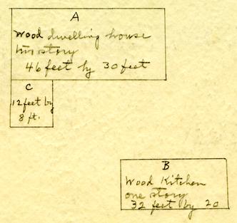
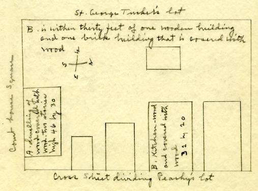
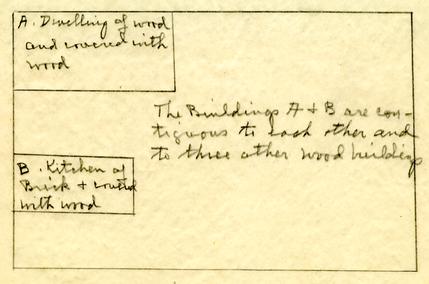
Sometime before 1796, Reverend James Henderson2 was the owner of the property. In 1796 he insured his property with the Mutual Assurance Society under policy #178. Henderson states that his buildings were in Williamsburg in the county of York, "... fronting the Court house square...and now occupied 9 by myself between the lot of St George Tucker and the Lott of [illegible] Hornsby." A diagram attached to the policy of buildings insured includes a wood dwelling house, two-story, marked "A," 46 by 30 feet, with annex marked "C," 12 by 8 feet; and a wood kitchen, one-story, marked "B," 32 by 20 feet. (See Illustration #3 for copy of policy.)
Williamsburg Land Tax Records for 1801 indicate that James Henderson held lots valued at $40. (Figure indicating the number of lots is blurred in the photostat.) In 1806, Henderson is taxed for 4 lots, valued at $70. (See Illustration #4 for list of tax accounts.)
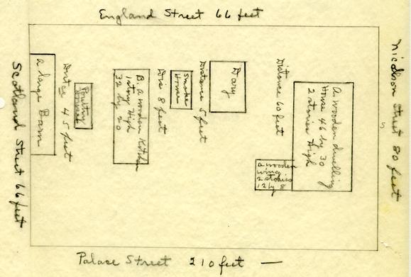
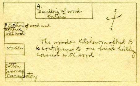
Also in 1806 Henderson's property was insured with the Mutual Assurance Society under policy No. 619, a revaluation of policy No. 178. Henderson described the property which was insured as " ... my two Buildings on the Court House Square ... now occupied by myself situated between the Lott of St George Tucker on the West and a cross Street running the aforesd square north course..." The dwelling house was valued at $2980. and the kitchen was valued at $250., face value of the policy being $3230. The wooden dwelling house was two stories high, 46 by 30 feet, and the wooden kitchen was one story, 32 by 20 feet. In addition to the buildings insured, the diagram attached to the policy sketches a dairy, smoke house, poultry house, and "a large Barn." (See Illustration #3 for detailed drawings as copied from photostat of policy.)
In 1815 Henderson's property is again insured with the Mutual Assurance Society, under policy No. 1523, a revaluation of policy No. 619. The buildings are noted as being located "on the Court House Square now occupied by myself situated between St George Tuckers lot on the West and Mary M Peachy on the east…" The dwelling was insured for $3375. and the kitchen for $300., total amount of insurance being $3675. The dimensions of the buildings insured were the same as in the previous policy. (See Illustration #3 for detailed drawing of policy.) The land tax records from 1810-15 indicate that Henderson paid 10 tax on 4 lots valued at, $100. (See Illustration #4.)
In the Southall Papers, College of William and Mary, there is a copy of the will of James Henderson, dated December 28, 1818. One item states: "I do authorize and empower my executors herein after named to sell all my Houses & lots in 'James Henderson' [?] the City of Williamsburg, all my land & Houses in the County of James City ...." Land tax accounts for 1818 indicate that Henderson held 4 lots valued at $150. (See Illustration #4.)
In 1820, a different system of expressing values on all land and lots in Williamsburg was used. Henderson's property, being noted as an "Estate," is listed as "1 lot," value of buildings being $1500, value of lot and buildings being $1650. (Ibid.)
By 1823 Walter W. Webb was the owner of the property as he insured his property in policy #5045, which was a revaluation of Policy #1523 formerly in the name of James Henderson. The dwelling was valued at $1667 and the kitchen at $450. (See Illustration #3 for drawing from photostat of policy.)
Land tax records for 1825 charge Walter W. Webb with 1 lot, on which the buildings are valued at $1500, total value on lot and buildings being $1650. Subsequent deeds (which appear later in this report) indicate that Webb was residing on this property until ca. 1835. Webb owned other property in the city. But it does seem significant that during 1825 Webb was charged by Richard T. Booker with considerable repairs and building. The total account amounted to $461.08. (Southall Papers, Folder 193, Legal Cases and Estates, College of William and Mary Library — copy in Department of Research.) There are bills for plank, scantling, sills, featheredge, shingles, pales for front of house, whitewashing, underpinning, window lights, shutters, laying up a chimney, etc. (See Illustration #2 for copy of full account.) One cannot be certain that this work done for Webb covered his houses on lot 171 but we believe it is probable from the nature of the repairs. Most of the 11 buildings mentioned are buildings usual around dwelling houses in Williamsburg, such as carriage house, kitchen, convenient house, stables, etc.
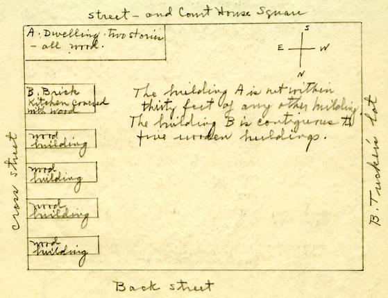
Webb's property was insured In May 1830 under policy #7606, a revaluation of buildings formerly insured per declaration #5045. Webb's property is described as "My buildings on the Court house Square in Williamsburg now occupied by John E. Browne's family situated between the lot of Lelia Tucker on the West, the Court House Square on the South and streets on the East and Worth..." The dwelling marked "A" is valued at $2000 and the kitchen marked "B" is valued at $400, making a total amount of $2400 insurance. A stable and a cotton ginning manufactory building are shown on the insurance plat. (See Illustration #3.)
In 1835 Webb was still the owner of the property as he is charged in the tax records with one lot on which the buildings are valued at $1500, value of lot and buildings being,$1650. (Land Tax Records for Williamsburg — Illustration #4.) Webb is listed as being from New York.
In May 1851 a deed of trust given by Jacob C. Sheldon to William S. Peachy listed among other lots and houses in Williamsburg the following real and personal property: "all that lot of land with the houses thereon in the City of Williamsburg wheron the said Sheldon now resides, adjoining the lot of Beverley Tucker, being the same lot purchased of and conveyed by Walter W. Webb, to the said Sheldon by Deed of record in the Clerk's office of the Hustings Court of the City of Williamsburg..."(Southall Papers, Folder 179, Legal Cases and Estates, James City County — suits against various persons, 1830-51.)
Land tax records for Williamsburg indicate that Sheldon held several lots. It is impossible from these records to identify the lot which Webb conveyed to Sheldon as no tax transfers are available. (See Illustration #4 for valuation of Sheldon's possible ownership of this lot until Charles Curtis came into possession of it.)
12From 1854-1861, the land tax records of Williamsburg list Charles Curtis as owning a lot as follows:
| 1854 | Charles C. Curtis | lot and buildings $3000; bldgs $2500 |
| 1859 | Charles Curtis of Gloucester County | lot and buildings $3600; bldgs $2600 |
| 1861 | Charles Curtis of Gloucester County | lot and buildings $3600; bldgs.$2600 |
The Land Book for 1865, Williamsburg Court Records, indicate that M. and Julia C. Thompson are charged with real estate in fee simple, the buildings being assessed at $2600, the lot and buildings at $3600. Notation is made "Transferred from Charles Curtis."(Land Book, 1865, p. 9, line 4.)
Mrs. Victoria M. Lee in recalling Williamsburg as she remembered it in 1861, wrote about the property:
"The present home of Dr. Garrett, belonging at that time to Mr. Montague Thompson, was known as the Thompson house. At that time, the house did not have its present kitchen wing, but otherwise its appearance is almost unchanged."("Williamsburg in 1861," p. 85, copy in Department of Research)
Another description of the house id given by Mr. John S. Charles in his "Recollections of Williamsburg" (pp. 34-35):
"The premises now occupied by Dr. Garrett were almost identical in appearance to what they were at the beginning of the Civil War, except that there has been a modern addition to the rear of the dwelling, and the old ice house that was at the northeast corner of the lot has disappeared."13
Thompson by will (dated July 27, 1893; probated October 9, 1893) devised his dwelling house to Miss Lottie C. Garrett for her natural life:
"[Item] 8th: I give to Miss Lottie C. Garrett for her natural life my dwelling house and — in the City of Williamsburg, Virginia. Should her sisters Miss Mary W. Garrett or Miss Susan C. Garrett survive her, the said dwelling house and lot are given to them for a home during their lives."
By deed recorded April 4, 1914, Lottie C. Garrett, Mary Winder Garrett and Susan Garrett Nelson conveyed to Van F. Garrett) with general warranty, their life interest in the property bounded "on the south by Nicholson Street; on the east by Chesapeake Street; on the west by the Coleman lot or formerly the Tucker lot and the lot belonging to Misses Cora and Estelle Smith; and on the north by a street running at right angles between Dunmore and Chesapeake Streets, and separating said lot from Harris' lot, being the life interest in the property devised to the said parties of the first part by the will of Philip M. Thompson, deceased, which was admitted to probate in the Clerk's Office of the City of Williamsburg, Virginia." (Williamsburg Deed Book, No. 6, pp. 476-7.)
Further and more detailed chain of title can be found in the Accounting Department of Colonial Williamsburg.
IN SUMMARY:
Colonial lot 171, on which the "Archibald Blair House" was erected, is situated on the lot on Nicholson Street facing Market Square with England Street on the east and the St. George Tucker lot on the west.
Trustees of the City conveyed to Archibald Blair on July 15, 1716, four lots designated 170, 171, 172 and 173 with the stipulation that one or more good dwelling houses be erected thereon within 24 months. Upon Blair's death in 1735 the property was owned by John Randolph. In 1763, Randolph, for a consideration of 825 pounds, conveyed the property to Peter Hay stating 14 that the lots were those "whereon James Carter formerly dwelt." Hay died in 1766. His widow, Grissell Hay, obviously exercised her dower rights by living on the property — possibly until her death in 1778. In October 1771, Dr. George Gilmer (it is thought by chancery suit) had come into the lots and conveyed same, valued at 500 pounds, to John Blair. Blair's death — only a few weeks later — revealed that he had devised unto his son, Dr. James Blair, "the houses and lots I purchased of Doctor George Gilmer where Mrs. Hay now lives, to him and his heirs forever." Within a year, Dr. James Blair died. His will is not extant but there is evidence in source material to indicate that his brother, John Blair, was his heir and later became the owner of the lots. John Wickham, lawyer, and James Madison, president of William and Mary College, were renters of the property for short periods following Dr. Blair's death. In 1796 an insurance policy (#178) of the Mutual Assurance Society shows James Henderson as owner and living on the lots. The property is described as "fronting the Court house square... between the lot of St George Tucker and the Lott of ________ Hornsby." The buildings insured were a dwelling marked "A" of wood, two stories high, 46 by 30 feet, with annex marked "C" 12 by 18 feet; and a wood kitchen marked "B" one story high, 32 by 20 feet. The Frenchman's Map (1782) shows a rectangular structure on what, apparently, was lot 171. The College Map (1791?) and the Bucktrout-Lively Map (1803, 1867) indicate Henderson in possession of property. Henderson's tenure of the property is noted in the land tax records from 1801 to 1820, when four lots are listed at varying valuations. Insurance policies of 1806 (#619) and of 1815 (#1523), written in Henderson's name, denote total valuations for dwelling house and kitchen as being $3230. and $3675., respectively. In 1825, land tax records show that Walter W. Webb had come into possession of one lot, with buildings valued at $1500., value of lot and buildings being $1650. In 1830, Webb's property was insured under policy #7606, which indicates that the property was "on the Court house Square...now occupied by John E. Browne's 15 family situated between Lelia Tucker on the West, the Court house Square on the South and streets on the East and North..." The dwelling marked "A" is valued at $2000 and the kitchen marked "B" is valued at $400. In 1851.. a deed of trust given by Jacob C. Sheldon indicates that Sheldon had purchased the property from Walter W. Webb. It appears that Charles C. Curtis of Gloucester County held the property for several years. Curtis was followed by Montague Thompson and Julia C. Thompson. Upon the death of Thompson in 1893, the property was devised to Miss Lottie C. Garrett. In 1914, Van F. Garrett came into possession of the lot by deed from his sisters, Lottie C., Mary Winder, and Susan Garrett Nelson. Chain of title from 1914 to the present time can be found in records in the Accounting Department of Colonial Williamsburg.
| Illustration #1 - | Maps |
| Illustration #2 - | Accounts from Humphrey Harwood Ledger and from Southall Papers |
| Illustration #3 - | Copies of insurance policies |
| Illustration #4 - | Williamsburg land tax accounts |
Mary A. Stephenson
Department of Research
(Report prepared by Mary A. Stephenson,
Research Assistant)
May, 1948
Footnotes
"Dr. George Gilmer, Jr. occupied an even more eminent position in the colony than his father. William Wirt declared that besides 'his eminence as a physician' he was 'a very good linguist—a master of botany and the chemistry of his day—had a store of very correct general science—was a man of superior taste in the fine arts—and to crown the whole had an elevated and noble spirit, and was in his manners and conversation a most accomplished gentlemen.'" (Quoted from Trent's English Culture in Virginia, p. 28, in Medicine in Virginia in the Eighteenth Century by Wyndham B. Blanton, p. 316.)
Illustration #1
Archibald Blair Lot
Block 29
 PHOTOSTAT COPY OF THE WILLIAMSBURG PLAT IN "WILLIAMSBURG, THE OLD COLONIAL CAPITOL" BY LYON G. TYLER
Illustration #2
| Dr | |||
| 1783 | th | ||
| Octor | 4 | To 40 bushs of lime a 1/ & 2 ½ bushs of Hair a 2/. | £ 2 5. - |
| To 4 Days labour a 3/ & Carting 2 loads of Sand 3/. | - 15. - | ||
| To Repairing plastering 36/. in the Dwelg House | 1 16 - | ||
| To 16 Bushs of lime a 1/. & 8 days labour a 3/. | 2 " " | ||
| To 340 Larths a 1/3 ½ 6 Days labr a 2/. | 1" 2 3. | ||
| th | |||
| 9 | To 12 bushs of lime a 1/. & 7 days labr a 3/. | 1" 13" - | |
| To laying Kitchg harth 3/9 & layg Kitching floor 8/9 | " 12 6 | ||
| To repairing larthing & plastering in Do & 3 other Rooms 40/. | 2 " " | ||
| To Repairing Kitchg Chimney & takeing down Stove and Oven 15/. | " 15. " | ||
| To laying Harth & Repairing chimney in back Room to kitchg | " 6 -- | ||
| 18 | To 3 bushs of Whitewash a 2/. & white-washg 4 Rooms a 4/6 | 1 4 " | |
| To White-washg 5 Ceilings a 2/3. 2 passages a 4/6 & 2 Do a 2/6 | 1" 5" 3 | ||
| To setting up a Grate 7/6 & laying a marble slab 2/. | " 9 6 | ||
| To Repairing Chimney in parlour 1/6 | -- 1" 6 | ||
| To 1½ Days labr a 3/. & 4 bushs of lime a 1/. | -- 8. 6 | ||
| £ 16 13 6 |
| to 1000 feet of T plank at $18 per 1000 | $ 18 00 | |
| to 90 feet of 1¼ T plank at 3 Cts per foot | 02 10 | |
| to 34 feet of 3 by 4 scantling at 4 Cts per foot | 1 36 | |
| to 15 feet of sill at 17 Cts per foot | 02 50 | |
| Sept 14th | ||
| to 72 feet of T plank at $18 per 1000 fet 72 --------- | ------ | |
| Sept 22th | ||
| to [illegible - 8? 6?] 70 feet of fetheredge plank at $18 per 1000 | ----- | |
| to 22 feet of plat at at 8 cts ---- --- | 07 76 | |
| to 86 foet [sic] of 1½ T plank at 4 Cts | 03 44 | |
| to 58 fet ½ ...[fo?] 3 by ... [illegible 4?]scantling at 4 Cts | 72 | 02 32 |
| 8 70 | ||
| 1 26 | ||
| to 126 feet of fetheredged plank at $18 per 1000 | 10:68- | 18 90 |
| Oct 4th 1825 | ||
| to 473 feet of plank | 4.73 | |
| Oct 10th | 10 63 | |
| to 1603 feet of T plank at $18 per 1000 | 15 36 | 27 61 |
| to 64 feet of T plank for grave | 01 28 | |
| to 104 feet of sill at 35-1/3 Ct $34.66 to 1650 feet of poplar fetheredge plank at 2 Cts per foot $36 .. | 165 66 | |
| to 1000 shingles at $3.50 Cts - $35 to 67 feet of sill for carage house $22.33 | 57 33 | |
| to 1000 feet of T plank $20 to 4000 feet of T plank for fence $80 | 100 00 | |
| to 62 sedar post at 25 Cts $16 to 192 sawed oak rails at 12½ Cts 23 | 39 00 | |
| to 50 feet of poplar scantling for frames & ills [sic] 5 Cts | 25 00 | |
| $344 31 | ||
| [page 38] ... | ||
| to puting up 10 - panels of pails in front of house at 75 Cts per panell | 07 50 | |
| to 12 post at 19 Cts each | 02 28 | |
| to laying one square of flour [sic] in poarch at | 02 50 | |
| to 24 feet of fatig at 4 Cts per foot | 00 96 | |
| to taking down 3 sqre of planking at 25 Cts per sqr | 00 87½ | |
| to Dit - - - - 3½ Dit. framing at - - D | - 87½ | |
| to framing of 3½ sqre at $1¼ per sqr | 4 38 | |
| to puting up 3½ Sqr of planking at $1 per sqr | 4 38 | |
| to puting under 15 feet of sill at 17 Cts per foot | 02 50 | |
| to turning arch over door - to kitchin | 62½ | |
| to plastering poarch $3:00 to underpining stable $4 | 7 00 | |
| to whitewashing poarch $30 to puting up steps 2:50 --- | [sic]3 50 | |
| underpining of convenient house $3 Dit plastering &c $3 | 06 00 | |
| 42 39½ | ||
| to puting in 5 windows sills at 63 Cts each | 03 15 | |
| to one 8 light frame $2 12 lights of sash 2.17 to shutter $3 | 07 17 | |
| to casing 3 windows & one door. $4. to puting 4 beeds to windows 50 | 04 50 | |
| to 40 feet of corner board $1.00 Cts to 7O feet of barge board at 4 Cts $2.80 | 04 40 | |
| to 64 feet of eve at 19 Cts $10.66 to 12½ square of weather boarding at $1.25 $15.63 | 26 69 | |
| 87 88½ | ||
| [Page 39] | ||
| to one greensill 25 Cts to pieceing 11 studs & on Hokeone [?] | $ 2 00 | |
| to shingling 2 dormors $2..50 .. 4 new cant & 4 new valey boards $3. to checking.. [do?]3 | 08 0 | |
| to 20 feet of cornis $2..50 to 10 feet of barge boards 40. | 02 90 | |
| to 12½ square of shingling at 1.25.. $15..63 to making fiting & hanging 3 doors $5 | 20 63 | |
| to puting Casing to cariage house door & ...[bar? Car?] and making &c compleat | 05 00 | |
| to making compleat a duble shutter for Dit | 03 00 | |
| to cuting away for to run Chimney to kitchin and shingling around Dit | 06 00 | |
| to taking roof of [sic] conveniant house & puting on Dit as per bargain | 10 00 | |
| to puting up 42 panels of planking at 75 Cts per panel $31..50 | 31 50 | |
| to Dit Dit 20 Dit Dit at 63 Dit | 12 60 | |
| to puting up 44 feet of poarch bench at 77 Cts per foot | 07 48 | |
| to glasing 6 pains of glass 39 to one strip to winder 16 | 00 50 | |
| to taking off 25 square of weather board & shingles at 25 Cts per sqr | 6 17 | |
| to 36 feet of plank for store fence at 2 Ct per foot | 00 72 | |
| to one sedar post 33½ cts to 2 rails at 25 | 55 | |
| $116 77 | ||
Illustration #3
A. Blair House
Block 29
Insurance Policy Mutual Assurance Society #178
James Henderson
April 21, 1796
"I the underwritten James Henderson residing at Williamsburg in the county of York do hereby declare for Assurance ... My wooden Buildings fronting the Court house Square at Williamsburg now occupied by myself situated between the lots of St Geo Tucker and the Lott of [blurred] Hornsby in the county of York...
| The dwelling house | marked A at | $1100 |
| The Kitchen | marked B at | 240 |
| The addition | marked C at | ---- |
| $1340 |
Insurance Policy Mutual Assurance Society #619 Revaluation of buildings insured per Declaration #178 as per endorsment
James Henderson
February 11, 1806
"I the underwritten James Henderson residing at Williamsburg in the county of York do hereby declare for Assurance my twobuildings on the Court house Square in this Town of Williamsburg now occupied by myself situated between the Lott of St George Tucker on the West and a cross Street running the aforesd square north cour[cut off] in the county of York...
| The Dwelling Houses | marked A at | $2980 |
| The Kitchen | marked B at | 250 |
| $3230 |
Insurance Policy Mutual Assurance Society #1523 Revaluation of Buildings formerly declared for Assurance by James Henderson per declaration #619
James Henderson
June 28, 1815
"I the underwritten James Henderson residing at Williamsburg in the county of York do hereby declare for assurance in the Mutual Assurance Society... my buildings on the Court House Square now occupied by myself situated between St George Tuckers lot on the West and Mary M Peachy on the east in the county of York.
| The Dwelling house | marked A at | $3375 |
| The Kitchen | marked B at | 300 |
| $3675" |
Mutual Assurance Society Insurance Policy #5045 Revaluation of Buildings formerly declared for Assurance by James Henderson per Declaration #1523
declared for Assurance by James Henderson per Declaration #1523
1823, April 15th
Walter W. Webb
"...residing at Williamsburg in the county of York... declare my buildings on my own land situated between the lot of St George Tucker West and the Courthouse square and street otherwise and occupied by myself...
| The Dwelling | marked A at | $1667 |
| The Kitchen | marked B at | 450 |
| $2117" |
Insurance Policy Mutual Assurance Society #7606 Revaluation of Buildings formerly declared for Assurance by Walter W. Webb per Declaration #5045
Walter W. Webb
May 20, 1830
"I the underwritten Walter W. Webb residing at Williamsburg in the county of York do hereby declare for Assurance ...My buildings on the Court house Square in Williamsburg now occupied by John E. Browne's family situated between the lot of Delia Tucker on the West, the Court House Square on the South and streets on the East and North in the county of York...
| The Dwelling | marked A at | $2000 |
| The Kitchen | marked B at | 400 |
| $2400 |
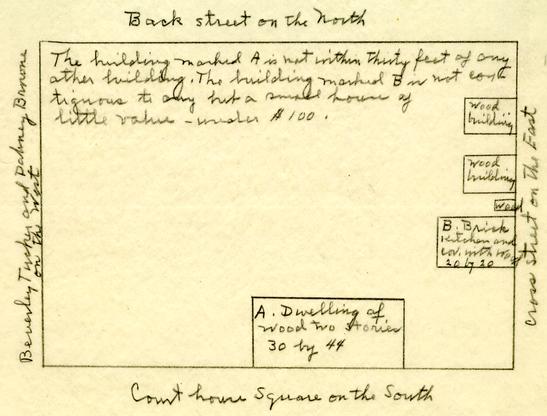
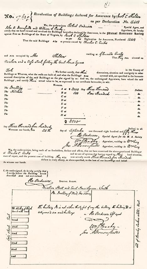
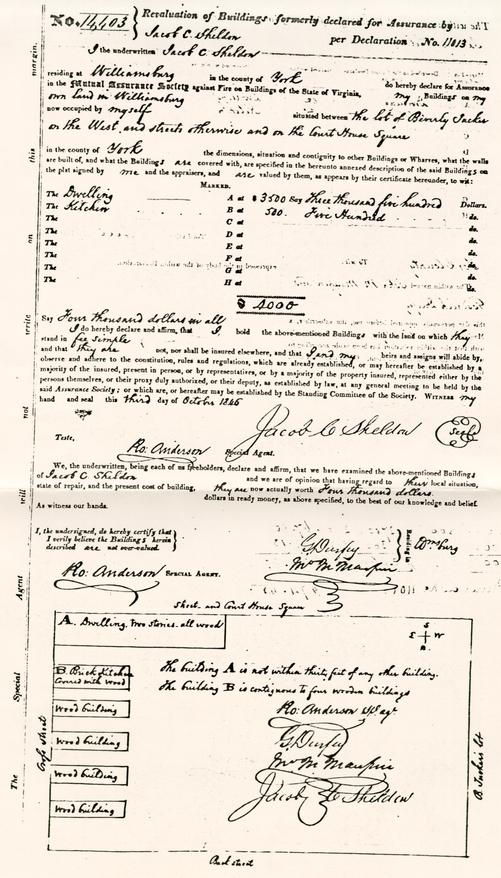
Mutual Assurance Society Policy #14403 revaluation of buildings formerly declared for assurance by Jacob C. Sheldon per declaration #11013
1846, October 3,
I the underwritten Jacob C. Sheldon residing at Williamsburg in the county of York do hereby declare for assurance... my Buildings on my own land in Williamsburg now occupied by myself situated between the lot of Beverley Tucker on the West and streets otherwise and on the Court House Square in the county of York...
| The Dwelling | marked A at | $3500 |
| The Kitchen | marked B at | 500 |
| $4000 |
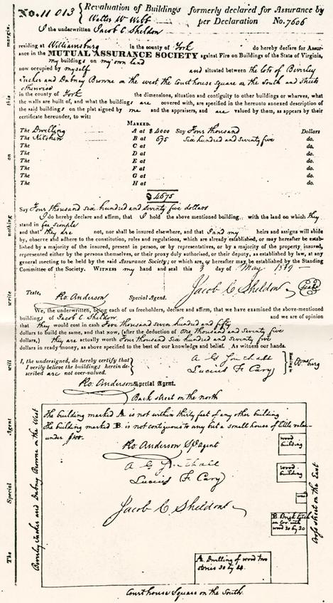
Mutual Assurance Society Policy #11,013 revaluation of buildings formerly declared for assurance by Walter W Webb per declaration #7606
1839, M1y 3,
I the underwritten Jacob C. Sheldon residing at Williamsburg in the county of York do hereby declare for Assurance... my buildings on my own land now occupied by myself and situated between the lots of Beverley Tucker and Dabney Browne on the west the Court house square on the south and streets otherwise in the county of York.
| The Dwelling | marked A at | $4000 |
| The Kitchen | marked B at | $675 |
| $4675 |
 Revaluation of Buildings declared for Assurance by Jacob C. Sheldon as per Declaration No. 14403
 Revaluation of Buildings declared for Assurance by Jacob C. Sheldon as per Declaration No. 11013
 Revaluation of Buildings declared for Assurance by Walter W Webb as per Declaration No. 7606
Illustration #4
Blair House History
Block 29
WILLIAMSBURG LAND TAX RECORDS
(John Blair lots before 1801 are not listed separately — hence are not copied here)
| No. Lots | Annual Value | |||
|---|---|---|---|---|
| 1801 | James Henderson | [blurred] | $40 | |
| 1806 | James Henderson | 4 | $70 | |
| 1810 | James Henderson | 4 | $100 | |
| 1812 | James Henderson | 4 | $100 | |
| 1815 | James Henderson | 4 | $100 | |
| 1817 | James Henderson | 4 | $150 | |
| 1818 | James Henderson | 4 | $150 | |
| 1819 | James Henderson | 4 | $150 | |
| Value of lots | Sum added to lots on account of bldgs. | |||
| 1820 | James Henderson | 1 | $1650 | $1500 |
| Value of bldgs | Value of lots including buildings | |||
| 1825 | Walter W. Webb - Williamsburg | 1 | $1500 | $1650 |
| 1828 | Walter W. Webb - Williamsburg | 1 | $1500 | $1650 |
| 1830 | Walter W. Webb - Williamsburg | 1 | $1500 | $16[50-blurred] |
| 1835 | Walter W. Webb (New York) | 1 | $1500 | $1650 |
| 1838 | Jacob C. Sheldon | 1 | $1500 | $1600 |
| 1840 | Jacob C. Sheldon | 1 | $1600 | $1800 |
| 1843 | Jacob C. Sheldon | 1 | $1600 | $1800 |
| 1847 | Jacob C. Sheldon | 1 | $1600 | $1800 |
| 1850 | Jacob C. Sheldon Williamsburg | 1 | $1600 | $1800 |
| 1854 | Charles C. Curtis (Gloucester County) | 1 | $2500 | $3000 |
| 1859 | Charles Curtis (Gloucester County) | 1 | $2600 | $3600 |
| 1861 | Charles Curtis (Gloucester) | 1 | $2600 | $3600 |
| 1865 | Montague Thompson & Julie C. Thompson | 1 | $2600 | $3600 "Transferred from Charles Curtis" |
NOTE: The Sheldon property valuations may be correct for the Webb lot and building. Sheldon owned other lots in the city. It is impossible to determine which of his lots were valued at $1800.
Illustration #5
Archibald Blair House
Letter dated "Wmsburg Jany 25th [no year]"
From Miss M. Blair to [St. G. Tucker]
Uncat. Mss Tucker-Coleman Collection, Colonial Williamsburg"It being impossible for Mr. Blair to answer Mr Tucker's Letter the Evening before he left Town, he Desired M: Blair to inform him that he was yet undetermined, whether he should possess the House & Lott next Mr Tucker's but that if ever he parted with it, it must be altogether —in-Mr Tuckers Wish as to the Trees, he will with pleasure gratifyhimthe one he observed, grew so near the House as to injure it, which was the Cause of its being cut Down, but he has order'd that not another shall be touch'd — the Servants however have taken advantage of the family's being absent, & some Winters ago cut Down several, should Mr Tucker observe any further Attempts on them, M: Blair will be much obliged if he will prevent them, & inform her father of it — her Mamma & Sister unite with her wish much to know what Accts Mr Tucker has had of Mr Theodr Randolph —"
Errata
[The following note was found within an electronic (.txt) version of the report. It does not exist within the print version]
Since preparing this report in 1948 the following piece of information about the Archibald Blair house has come to me through Goodwin: At a Court held for York County of Oyer & Terminer, April 4, 1728, (Sarah a mulatto slave belonging to Archibald Blair, Gent. being indicted by William Robertson, attorney for the King, for "that on the 15th day of March last with force and Arms of her Malice aforethought did Set on fire and [sic] part of the Mansion house voluntarily and feloniously bum against the Peace of our Lord the King... she pleaded Guilty... the Court... were of Judgment that she ought to suffer death for the said Crime and therefore do award that she be remanded to Prison and from thence be conveyed upon the 17th Instant to the place of Executeon and there be hanged by the Neck till she is dead." She was valued at L18 &c
York County Records, Orders, Wills, Book XVI P 511(part II)Mar7. Stephenson September 1951.